El Roblón de Estalaya
- Home → Trails Montaña Palentina → El Roblón de Estalaya


Route Description
To reach the starting point of this route, you need to take the road from Cervera de Pisuerga towards Potes. After crossing the bridge over the La Requejada reservoir and passing the village of Vañes, there is a road on the right. Take that road, and after about two kilometers, you will find a parking area. This is the beginning of the route.
From the parking area, follow a clear and well-marked path. Cross the tail of the La
Requejada reservoir via a bridge, and shortly after, you will come across a fork in the path.
Take the left branch, which ascends to the “Roblón” through a small valley. After passing through a metal gate, you will enter a magnificent mixed forest of beech and oak trees.
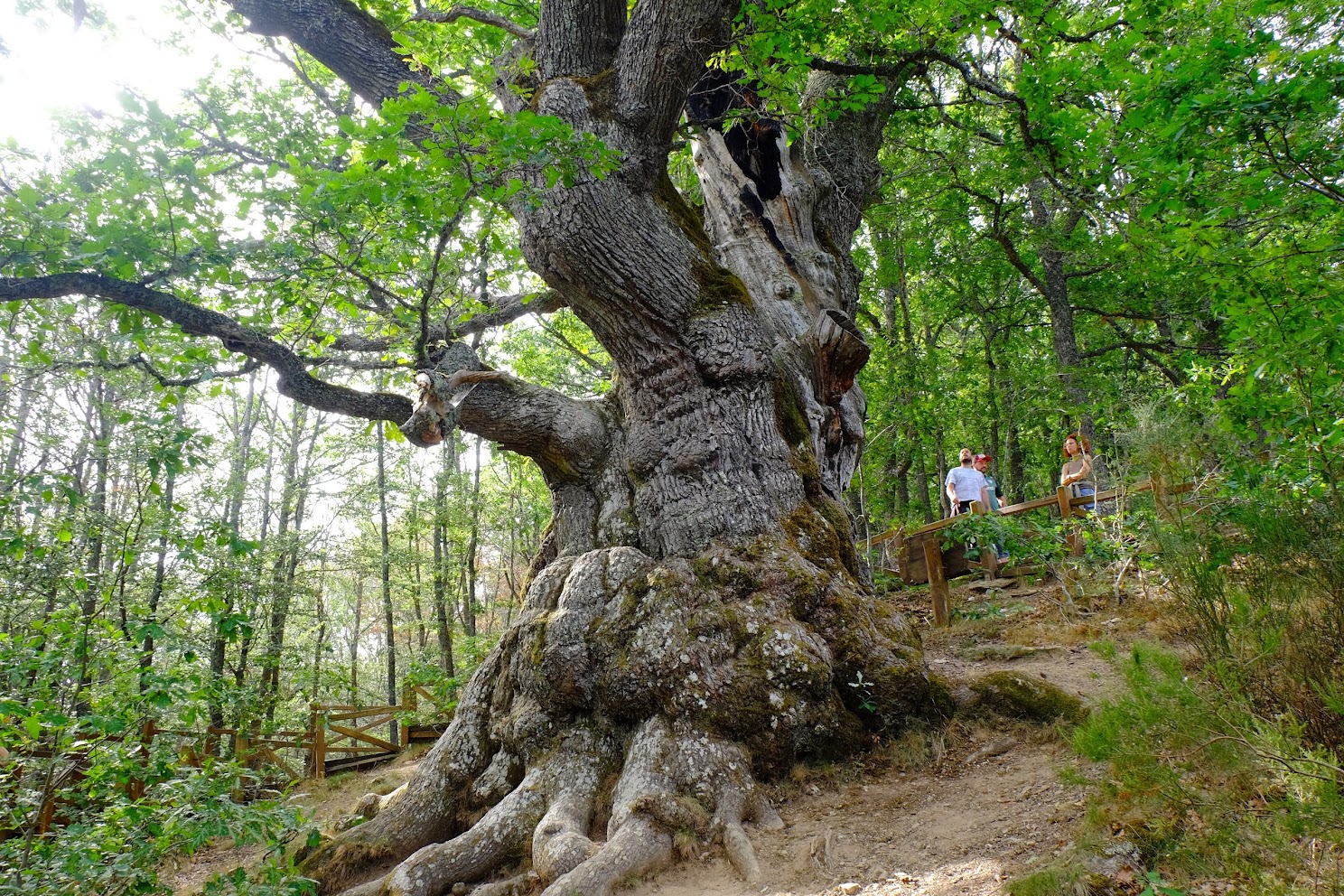
Soon, you will be amazed by the impressive size of the “Roblón” of Estalaya.
The “Roblón” of Estalaya is a notable and venerable specimen of English oak (Quercus petraea). It stands at a height of 17 meters, with a perimeter of 10.6 meters at its base.
There are differing opinions about its age, but it is certainly over 500 years old. Some
experts believe it is 800 years old, although many locals claim it could be much older. This “grandfather”, as it is known among the people of the region, has survived a lightning strike that left a mark on its trunk and the ax of humans, which marked it for felling fifty years ago, although it was not actually cut down. Today, it is included in the catalog of notable trees of Castilla y León. It is protected by a fence surrounding its impressive trunk, and it is important to respect this boundary.
After taking the time to admire the “Roblón”, the path continues through the deciduous forest, where you will find beech trees (Fagus sylvatica), English oaks (Quercus petraea), and Pyrenean oaks (Quercus pyrenaica), as well as holly, hawthorn, wild service trees, and spindle trees. In the meadows and stream banks, you can find abundant herbaceous plants such as buttercups, wild mint, geraniums, wood avens, and primroses. Spotting forest wildlife may be more challenging as they are elusive, but you may hear the songs of birds hidden in the forest and come across traces of their presence (fur, droppings, feathers, etc.).
Descend through a small valley until you reach the reservoir again. The path continues
parallel to the reservoir, connecting with the section you walked at the beginning. Cross the reservoir tail using the same bridge and return to the parking area.
Route Details
Difficulty
Easy
25%Approximate Time:
- 1 Hour 30 Minutes
Distance
- 4,6 Km
Elevation Gain
- 125 Meters